Ross Sea Environmental Awareness Manual published 2025
ERA published the 1st Edition of the Ross Sea Environmental Awareness Manual in December 2025. The manual was commissioned by National Programs operating in the Ross Sea, including Germany, Italy, New Zealand, South Korea and the United States.

Ross Sea EAM cover - Cape Hallett; © ERA 2025
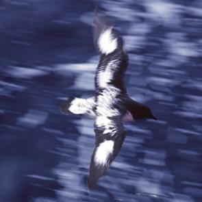
Antarctic Peninsula Wildlife Awareness Manual published 2021
ERA published the 2nd Edition of the Antarctic Peninsula Wildlife Awareness Manual (WAM) in May 2021. The manual was commissioned by the Germany, the United Kingdom and the International Association of Antarctica Tour Operators (IAATO).

WAM cover - Chinstrap penguins, Useful Island; photo © Noah Strycker 2019
ASMA No. 5, Amundsen-Scott South Pole Station Management Plan Revision
ERA updated and revised the management plan for Antarctic Specially Managed Area No. 5 Amundsen-Scott South Pole Station on behalf of the US Antarctic Program (USAP). Changes were made to the zones within the Area to maintain consistency with the latest policies of the Committee for Environmental Protection and to simplify the plan. Adjustments were made to the size of the Operations Zone and Quiet Sector to take account of practical operational experience and needs since the Management Plans first adoption in 2007. The approach guidelines for non-governmental visitors were revised. The plan was successfully adopted at the 2017 Antarctic Treaty Meeting held in Beijing, China.
ERA conducts Artisanal Mining Footprint Assessment
ERA was tasked by Estelle Levin Ltd (ELL) to quantify the spatial footprint of land affected by mining in the Mogok region of Myanmar. The mine footprints are part of an appraisal of the impact of gemstone supply chains to meet corporate environmental and social responsibility objectives. A pilot study was undertaken to develop and test a methodology. EU Sentinel-2 10 m ground resolution imagery was used in the analysis.
Antarctic Field Season 2016-17
ERA Director Dr Colin Harris and GIS Specialist Katharina Lorenz spent one week at Palmer Station, Antarctica carrying out a site visit on behalf of the US Antarctic Program (USAP). The fieldwork was focused on inspecting designated zones inside Antarctic Specially Managed Area No. 7 Southwest Anvers Island and Palmer Basin. A particular highlight was a rapid baseline assessment of the Rosenthal Islands Restricted Zone, with support from the RV Laurence M Gould. The island group is virtually pristine and hosts large penguin and other seabird colonies (petrels, terns, gulls).
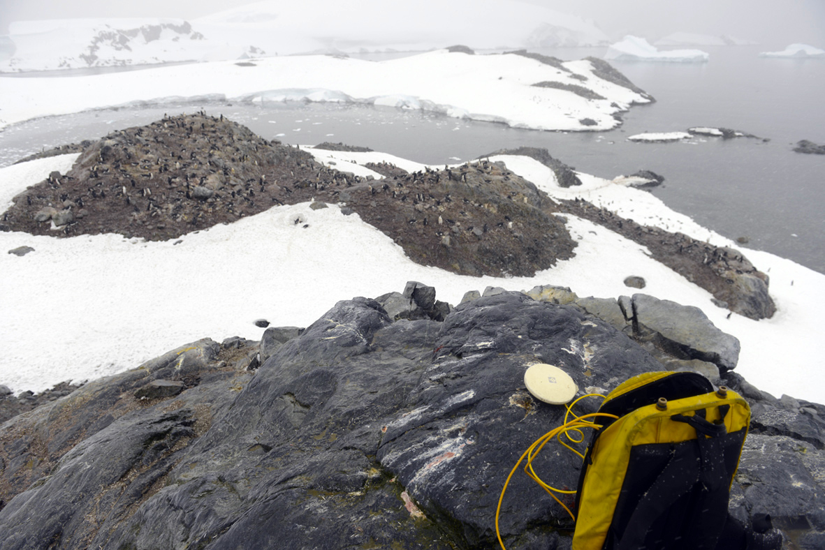
Collecting a Ground Control Point at Rosenthal Islands; © C Harris 2016
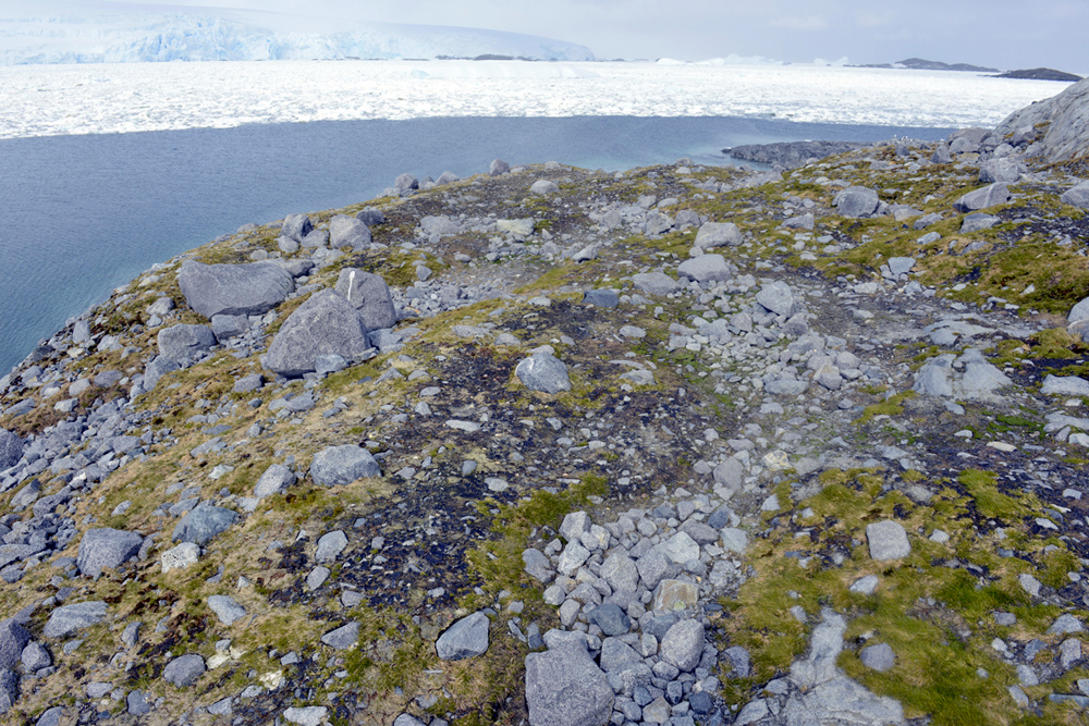
Inspection of seal haul out impacts on local vegetation; © C Harris 2016
Cambridge Connect initiative for sustainable public transport in Cambridge
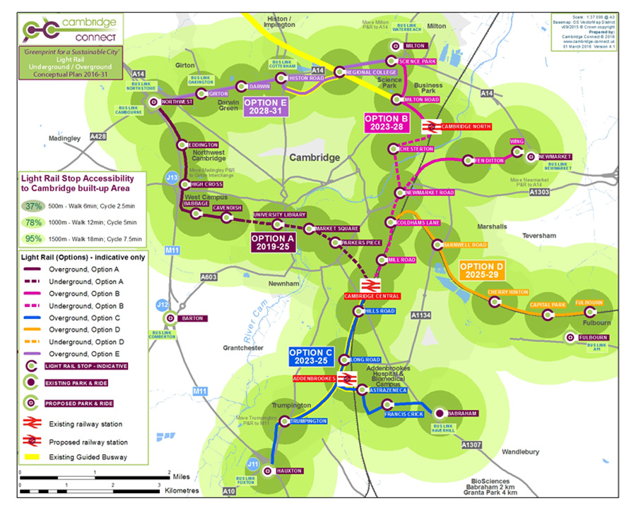
Greenprint for a Sustainable Cambridge
Cambridge Connect is a new initiative launched by Dr Colin Harris to promote light rail as a positive alternative for sustainable future public transport in Cambridge, United Kingdom. Cambridge is experiencing unprecedented and rapid growth, driven by the success of the University of Cambridge and of the high-tech science businesses locating here, coupled with its strategic location close to the financial resources of London. As a result, pressures on housing and transport have been mounting, and movement around the city is now regularly in gridlock. Local and central government have recognised that something needs to be done, and a package of funding up to £500M known as the 'Cambridge City Deal' has been agreed to provide a range of measures to address the problems. The principal transport measures being put forward in the City Deal are for new busways to be constructed along most of the radial routes leading into Cambridge, with the objective of speeding up public transport and making it more frequent and reliable.
Many local residents are expressing concerns about the environmental and social impacts of these bus expressways that would drive through their communities. Moreover, no clear plan seems to exist for what will happen to the buses arriving into the city centre once they reach the historic city core. With the rate of population growth and the aim to get more people using these buses, some estimates suggest that in 10-15 years around 200-300 buses per hour would be necessary to transport people into and out of the city. It is unclear where these buses would park to pick up and drop off passengers, or how they would practically move freely on the narrow and congested lanes within the city core.
Cambridge Connect was established out of concern that this approach could have a significant impact on the values of the historic city of Cambridge, including for the globally outstanding heritage landscape, for air quality, inner city amenity, and for the safety and comfort of other road users such as cyclists and pedestrians. Cambridge Connect examined alternative approaches to public tranport provision in Cambridge, considering models used elsewhere in Europe, with the conclusion that light rail with an underground component within the historic city core would represent a much more sustainable approach over the medium to long-term. While very much more expensive right now, Cambridge Connect suggests that this is an investment worth making for a city of such outstanding global importance as Cambridge.
More information on the initiative can be gained from the Cambridge Connect website.
ERA staff supports European Refugee Response Project
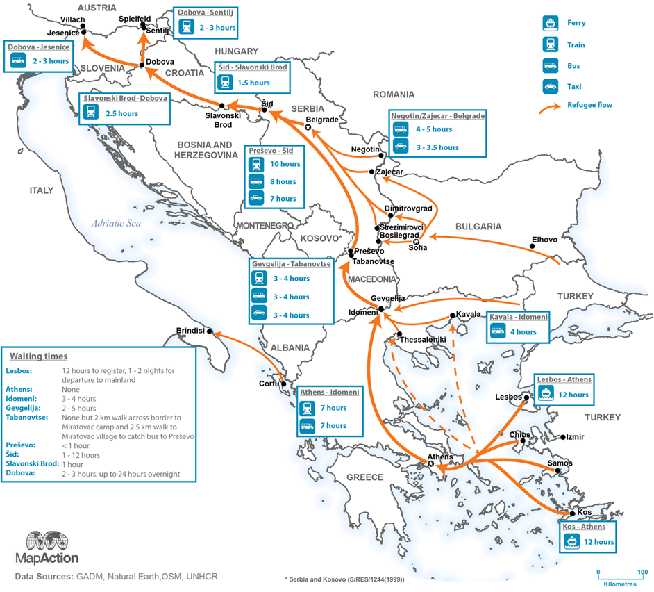
Refugee travel times and transit routes
The Assessment Capacities Project (ACAPS) and MapAction recently launched a project to provide an analysis of migrants in transit through the Balkan countries and the consequent humanitarian situation. The project, funded through the Start Network, was initiated in October 2015 and will run till March 2016. Scenarios, analysis briefings, maps and other visuals are published at regular intervals to inform both immediate operational and strategic decision-making related to the crisis. ERA staff member Katharina Lorenz is supporting the project in her role as a MapAction volunteer as a data visualisation analyst for a two month period. Katharina's GIS and cartography skills have made a key contribution to the project through her clear and informative graphics communicating the nature and the scale of the problem.
ERA produces maps to support fieldwork of Estelle Levin Ltd (ELL) in Liberia
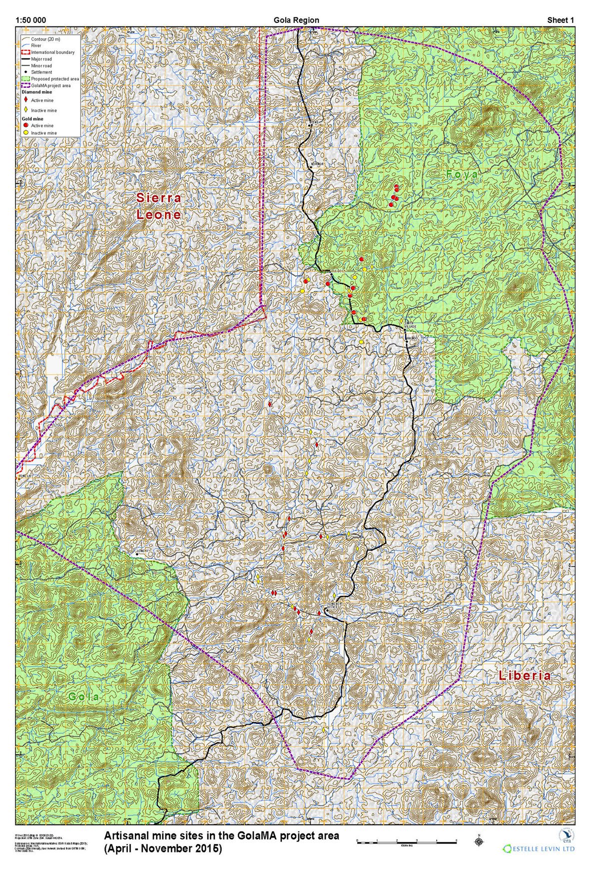
Artisanal mines in the GolaMa project area
ERA was contracted by Estelle Levin Ltd to produce maps for their fieldwork conducted in the Gola region of western Liberia. The work also included the modelling of a river network from a digital elevation model using GIS tools. ELL's aim is to identify strategies for responsible artisanal mining practices in the area. This work is part of the GolaMa project, a partnership between the Government of Liberia, local forest communities and international conservation agencies. The objectives of the GolaMa project are: (i) establish Community Forest Management Agreements (CFMAs) and financial sustainability business plans, (ii) ensure forest communities are benefiting from new, sustainable, alternative income generating activities under CFMAs while contributing to forest protection, (iii) reduce bushmeat hunting/trading of protected species in the project area, (iv) establish self-regulated sustainable artisanal mining practices, and (v) determine the potential of carbon trading to provide sustained finance.
Design & Construction: ERA
© Environmental Research & Assessment (ERA) Ltd.
Last Update: 23 February 2026